Day 193: Glenmore to Plocaig
Distance: 18.91 miles
Ascent: 2958 feet
Weather: SUnny
Accommodation: Wild camp Plocaig
Today was planned to be a very short day (8.5 miles) due to the lack of shops etc over the next few days so stopping in Kilchoan which had a shop would make things a lot easier. I was also not expecting it to be the easiest 8.5 miles as over half of it was planned to be off piste. I was telling myself and agreeing not to extend if I got to Kilchoan and felt good.
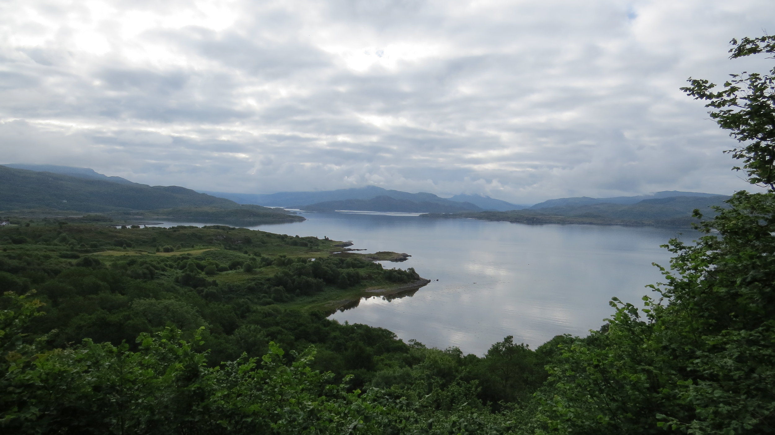
The first 2 miles or so were plain and simple following the single track road before reaching a little carpark where there was an information board about the history of the area and some of the ruins/stones and in fact these were very impressive, with a 6000 year old burial mound and a standing stone possibly 4000 years old. There was a little path down to the beach and then from this point I was essentially off piste following the shingle beach and sheep/cattle tracks.
It was obvious from fairly early on that my issues would start from the rocky headland (Maclean’s Nose on OS map) as it looked like the steep rocky slope may come straight down to the sea not allowing any way along the shore. But there was just enough room below this and following the steep grass verge and some rock scrabbling I had got around fairly easily I felt and sat down for a break.
How mistaken I had been on standing up after my break I wondered why I had been so stupid to think I had done it, as clearly the worse was to come with sheer rock faces and jagged coastline to come though I could see where it would get easy in probably only 500m or so time. When I reached the rock sections I really considered turning back as it was on my limit, and on the edge of being dangerous but I decided it was just the safe side of dangerous so continued. I waded around one of the jutting out stone sections which was fine, and then had to climb one before following the top of the stone sections which were now much easier. I reached the end and was mightily relieved as it was exhausting this short section.
From here it was simple walking firstly on a farmers track passing Mingary castle which appears to have been converted for living in and in my opinion not to tastefully, and then on the single track road again into Kilchoan where I arrived about 12:30. So the 8.5 miles had taken me 4.5 hours!
The weather was perfect for walking sunny with a breeze and the weather tomorrow was meant to be quite wet so even though I had told myself not to extend the day I couldn’t help myself and knew to make the extension work I would have to add on a good 10 miles or so. The shop in Kilchoan was good (and luckily for me open till 1pm) so I got some food for lunch and also stocked up for the next few days. I must thank Ardmurchurn Campsite in Kilchoan who had kindly offered me a free pitch for tonight but due to my extension I would unfortunately not be using it.
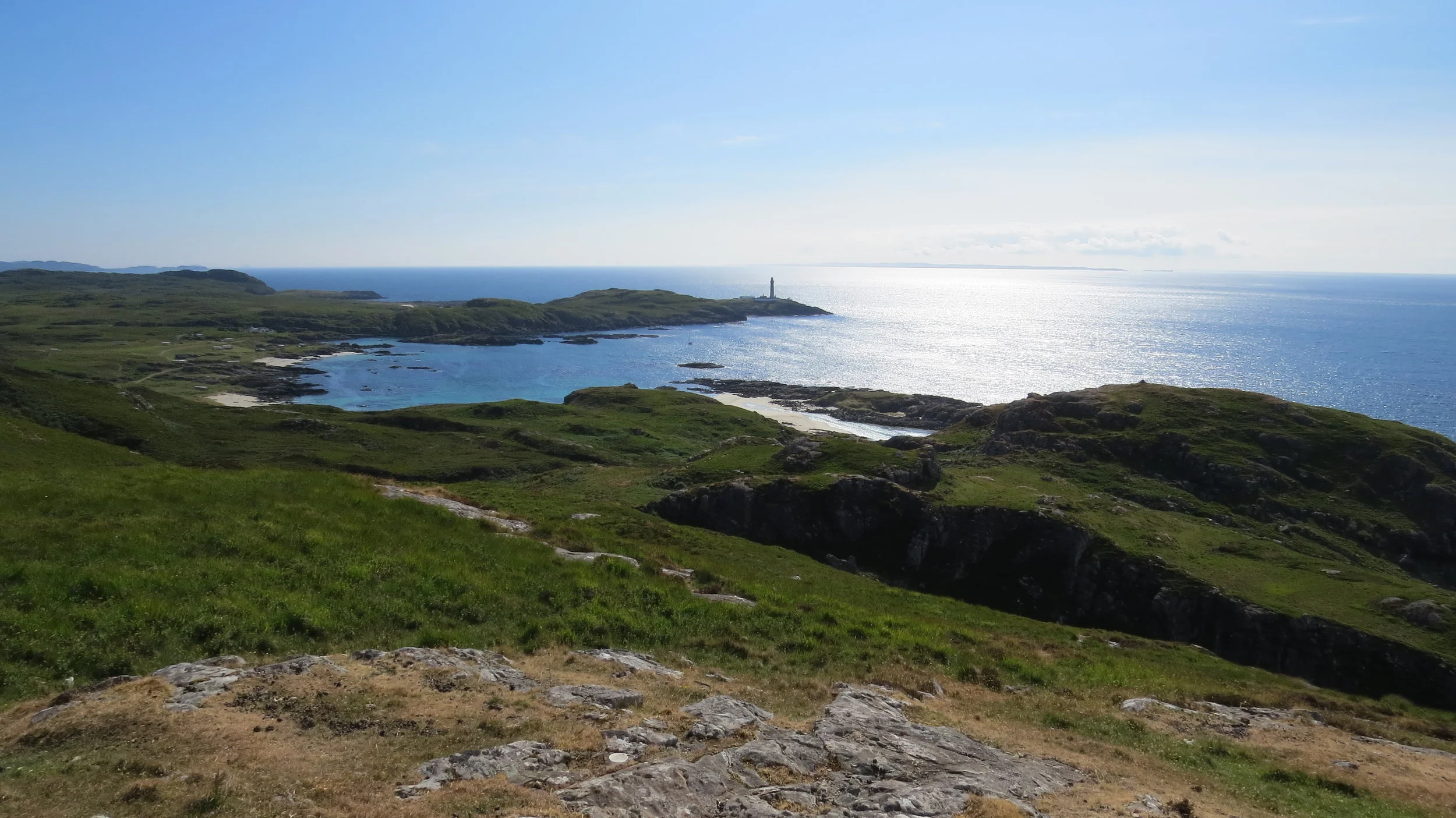
From Kilchoan I had 6 miles of single track road section all the way up to Ardmurchan Lighthouse, this was another incredible road with stunning mountainous surroundings. I was hoping to get to the lighthouse by about 3 as one of the reasons the extension was also decided upon was I had found out that they had a little café at the lighthouse where I was hoping to charge things up for an hour or so. I did indeed get there about 3pm and the views from here were incredible. It is in fact the most westerly point of mainland Britain (though my OS map thinks not due to a headland a kilometer further south) and thus for some previous coast walkers a significant point but because I have stupidly included islands linked by bridges my most westerly point is not for a few more weeks yet on Skye. I did manage to charge things up a bit and also picked up a bit of signal which was useful just to redownload OS map for the extended area.
From the lighthouse I had to retrace my steps for half a mile or so before I was hoping to head along a track that went through a caravan park that I believed was also a core path. But it had a high gate which was locked so I looked around and realised at the little bridge I could easily get access there. Once inside I followed the track and indeed then I saw core path signs (I know! Scotland seems to have actually embraced core path signage in this area) and as I had hoped I could follow this up to the cairn.
Wow! The views from this cairn even by this walks standard were something else back to the lighthouse but also down to the incredible white sand beaches of Portuairk and Sanna and their turquoise waters. From the cairn there was a path down to Portuairk and once in the village I decided I would head to Sanna and then stop.
The path from Portuairk to Sanna was well directed and after not too long I descended down to the perfect white sands, this beach is often in the top 10 lists. Once here I thought I would just push it a little further to get more remote and reach the ruined village of Plocaig. There was no path for this bit but it was not too hard under foot and once at Plocaig I headed a hundred meters towards the shore and found a lovely spot to pitch, one of my favourites so far, looking out to Skye in the distance. The only downside was sharing it with sheep but hopefully they don’t take a liking to the tent in the night.
The extension was definitely the right decision as doing such a beautiful section as the lighthouse and Sanna in the rain would have been a right shame. And I have gone far enough that tomorrow, which would have been a very tough day, should now be fairly easy hopefully. Essentailly an all round great day, apart from the rock climbing this morning.
NB - too many photos for me to cut it down to 12.
NB - If any one attempting a coast walk reads this do not attempt my route around Maclean's Nose you will not thank me for it.