Day 286: Horden to Middlesbrough
Distance: 27.35 miles
Ascent: 1217 feet
Weather: Rain Most of the Day
Accommodation: Sam & Andrew’s House, Middlesbrough (kindly Offered)
The tent had been just sheltered enough last night. I think without the little bank I had pitched behind the tent would have been flattened but even with the bank the tent was still flexing a lot and it did wake me up a few times. When I woke up in the morning the wind had completely dropped and it was raining which was not forecast when I’d looked yesterday morning , but on checking the latest forecast it was for rain all day.
The rain stopped for about an hour luckily as I was depitching which was very kind of it, and then I was on my way along the beach. I had thought this beach was a bit strange when I reached it last night as it almost felt manmade and having slept on it (not in the physical sense!) I think it must have been created with the spoils of a nearby ex colliery as it contained fragments of black presumably coal and appeared to have been compacted into a flat shelf. I followed the beach for a couple of miles until it began to disappear and then rejoined the coast path up on the low cliffs. The rain had now started and would get steadily heavier over the next few hours.
I actually crossed Hartlepool Golf Club on the coast path, which I could probably have avoided with afterthought by going along the beach. But the golfers on this course were all polite and I waited for a couple of groups to take their shots, and a couple of groups waved me through. There was one moment when I thought I was far enough away and it turns out I wasn’t when I suddenly heard loud shouts of ‘Fore’ and I wasn’t entirely sure what to do so I just turned around and covered my head. I heard the ball land and the guy had sliced it so far to the right it had almost landed on the next fariway and about 10m short and to my left. So, I suppose I was just far enough away where I was waiting.
I followed the path and beach around ‘The Headland’ (I think it is actually called that) on the edge of Hartlepool and then the coast path followed the dual carriageway around the back of the closed of harbour area. This was not particularly fun in the rain, and the path actually crossed the dual carriageway a couple of times, which was surprisingly hard to do as the road was very busy so you had to wait for quite a while for a small gap and then cross very quickly. I am sure in time the English Coast Path will make this little section better.
I turned off into the marina which contains the Historic Quay and Ships, and over the roof of a low building I could see the masts of a very impressive old tall ship. If it hadn’t been tipping it down I would have detoured the 500m or so to get a better view of the ship and quay but I just carried on around the marina. At the end of the marina there were a row of cafes and restaurants and a couple were open and having walked for several hours already and completely soaked I decided to have a little break in the warm and dry.
It is always a little embarrassing walking into a café in the state I was, literally dripping everywhere but I have learnt to not worry and just keep my wet stuff on hard surfaces only. The café was called Café Rappor Bar and I had a tea and snack and it was great to be in the warm and dry. One of the people within the café came and asked what I was doing and I explained the walk and to my surprise and very kindly she said that my stuff was complimentary, which I was very thankful for.
The rain had got worse whilst I was in the café and I knew I was going to be soaked but fortunately I would be in a warm house with a bed tonight. I took a promenade along to Seaton Carew and then followed the England Coast Path alongside a golf course out towards the dunes, and as per on my map it then just stopped in the middle of nowhere near a chemical works and it would not restart again for many miles until the other side of the River Tees. I am quite fascinated by path design now and the England Coast Path (which is meant to but won’t be completed by 2020) has great information about their proposed/completed routes and after reading there stuff this evening they as I had found when trying to plot a route through the next stage to the Newport Bridge had some trouble and in the end their proposed option is slightly boring but probably sensible to build a new path that follows the main road but who knows when this will get built but it has not even started yet.
My proposed route was to follow this road anyway as on google maps it appeared there was a mowed verge. It started well with a pavement as far as Graythorp Industrial Estate. At Graythorp Insustrial Estate the pavement stopped and contrary to my believe the verge was so overgrown to be impossible to walk and the road was to busy to walk along it so I had an issue. I got my map out and looked to see if there was an alternative. There was a little footpath out of the back of the industrial estate that would get me up to Greatham, and then I could follow more paths across farmland/nature reserve to Cowpen Bewley. I would have to join roads from here through the industrial areas but hopefully the first road would be quiet enough to walk and then when I rejoined the main road near the River Tees as it was now nearer the town I was hoping it would have a pavement. In essence it all worked as I had hoped, though obviously longer than original route, and the rain even stopped around 4ish when I went through Cowpen Bewley. Having now read the England Coast Path documents for this section it is interesting to see that they did consider a route very similar to mine but declined it on the basis that you can’t take dogs through the nature reserve and I hadn’t ever realised that the route has to be dog friendly as well.
I crossed the river on the Tees Newport Bridge, this is lift bridge (though has now been fixed permanently in its lowered position) and what a lift bridge. A completely mad but brilliant design built in the 1930’s to allow a fairly significant span road bridge to be vertically lifted to allow ships underneath. I have not personally seen any bigger lift bridges than this and it is a slight shame they have now fixed it permanently in its lowered state.
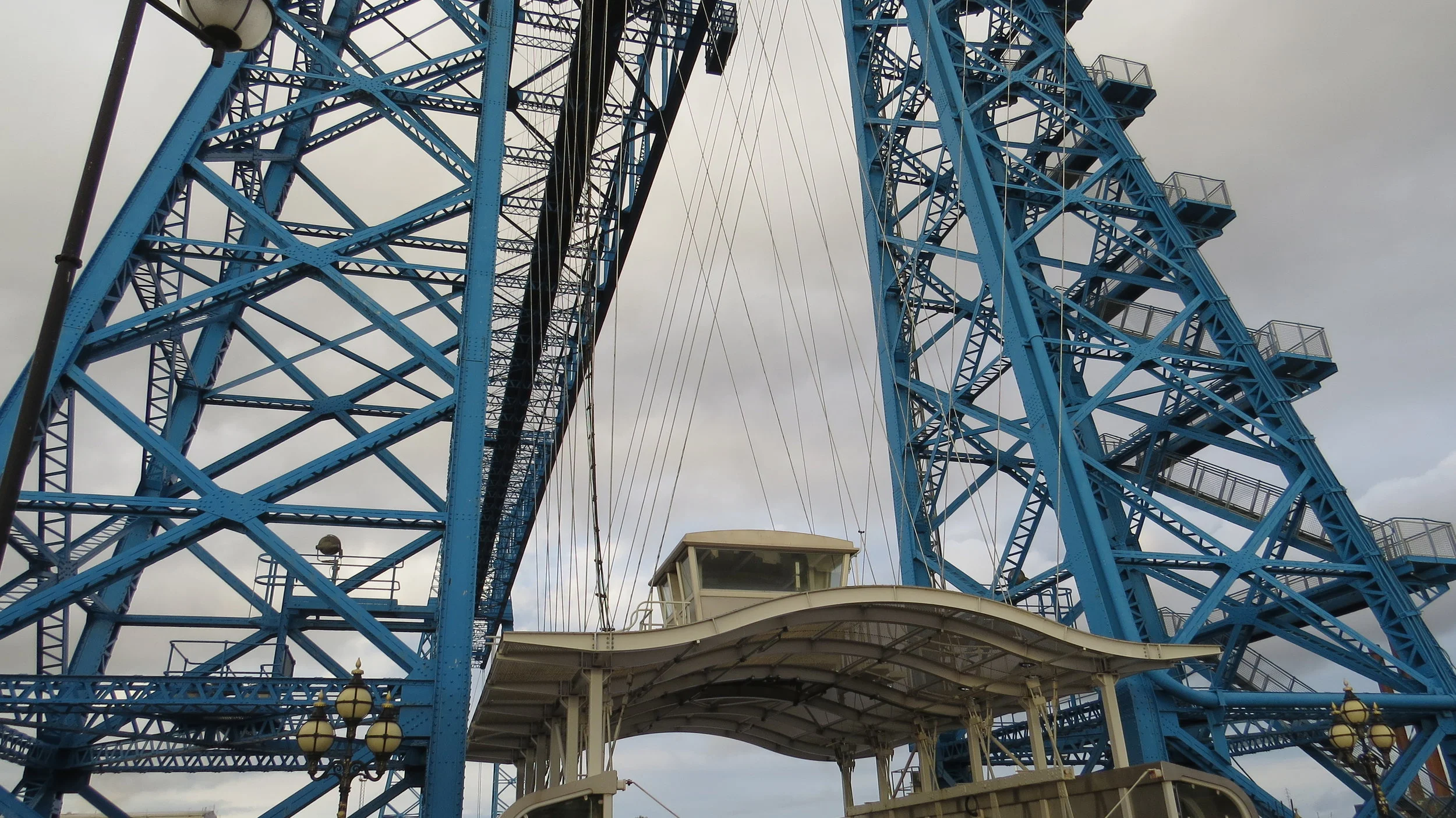
From here I rejoined the coast path and it was an easy couple of miles along the Tees to the Transporter Bridge where I would be finishing today. This is another incredible bridge like the Newport Transporter Bridge I passed months earlier on the walk where a sort of gondola is used to carry cars and people across the river. This one still functions everyday apart from Sundays and today being a Sunday was the reason I hadn’t crossed here. It was a real shame that my camera was in my bag and my phone had now run out so I was unable to get any good pictures of either bridge.
Grandma Judie had kindly come to pick me up at the bridge to drive me the short distance to her house. I would be staying with her grandkid Andy and his partner Sam who lived next door, who had kindly offered to put me up. They are relatives of Nigel and Lorna whom I stayed with down in Combwich. Andy and Sam made a lovely dinner and guess what the unofficial pudding of the walk Sticky Toffee Pudding came out again.
I am actually on another rest day, and will use this one to sort out the East Coast and contact the variety of people whom are wanting to join when I am a bit nearer London which will be nice.
A very wet day but now in a lovely place, with lovely people for my rest day.
NB - Again due to the rain not many photos which is a shame as with my camera could have got some great industrial shots today.